
Mike Malamen
Michael Malamen, of Champlin, Minnesota, served in the US Marine Corps as a forward observer and was stationed in central Vietnam from 1968 to 1969. The majority of his time in-country was spent in and around the A Shau Valley, near the Laotian border, under the jurisdiction of I Corps.
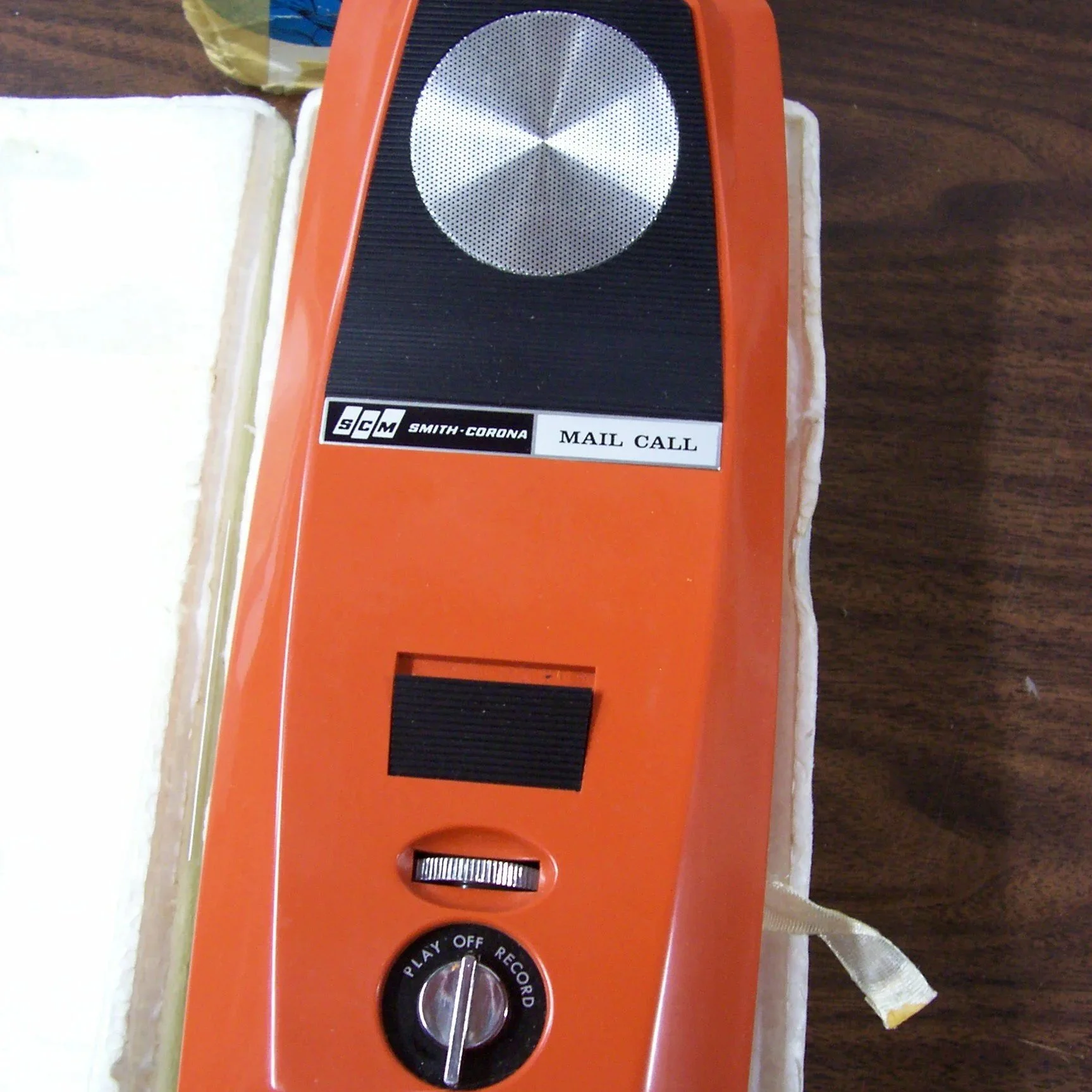
Smith-Corona "Mail Call" voice cassette recorder, ca. 1960's. The device is slim, orange, and made from hard plastic with slots for 4 “C” batteries a cassette tape. This belonged to Sam so he could record letters home. (Object ID 2531)
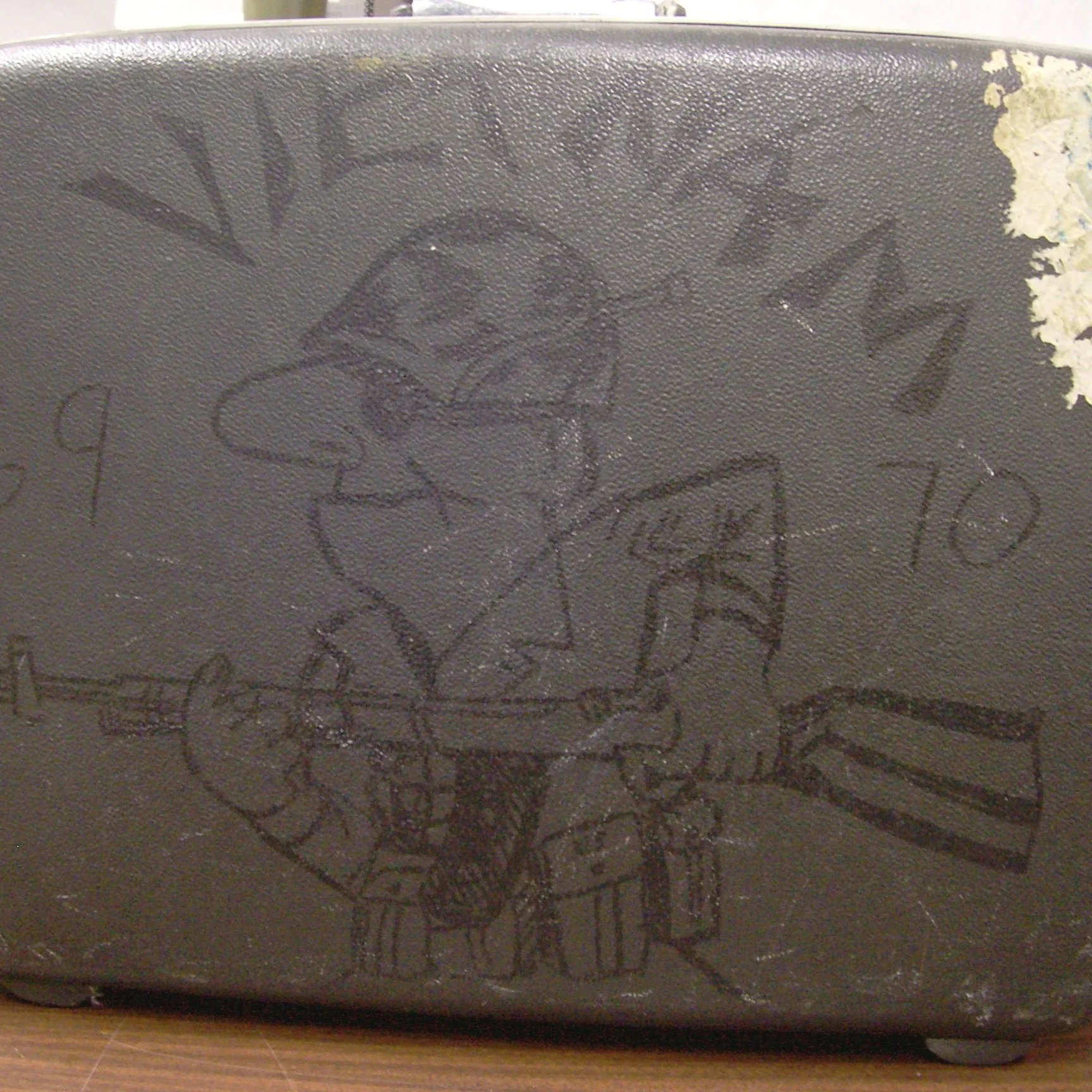
After his tour in Vietnam, Sam sat at a train station in Weisbotton, Germany for RR (rest and relaxation) when a fellow soldier drew “trench art” pictures using a magic marker on both sides of his suitcase. (Object ID 2007.1390.002)
Sam made the most of every situation, including befriending a stray dog in Lai Khevn, Vietnam in 1969. Notice the mosquito netting he rolled up around his bunk, which is inside a large tent. (Object ID P2069.6.30)
Finding You Way
xxxxx
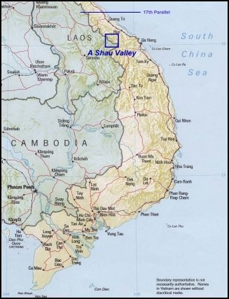
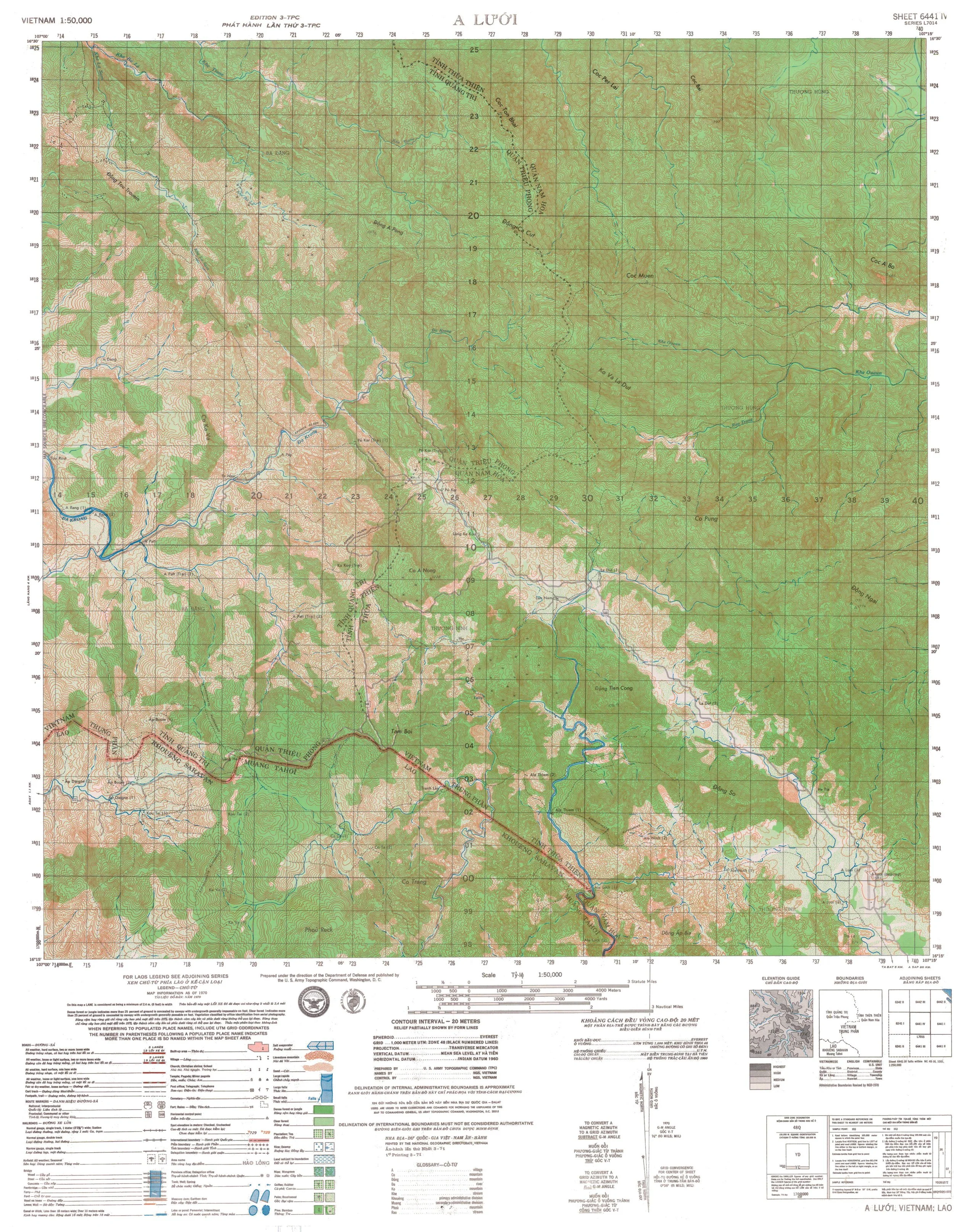
This is wider view of the A Shau Valley in Vietnam. On the right is a topographical map like Mike would have used to navigate the area.
reading a topographical map
To do his job, Mike needed to read a map like the one on the right. The tips below will help you decipher the language of map-makers.
Understand the Contour Lines: Contour lines represent elevation. Each line connects points of equal elevation. Close lines indicate steep terrain, while wider spaced lines suggest gentle slopes.
Identify the Scale: Check the map's scale to understand distances. For example, a 1:24,000 scale means 1 inch on the map equals 24,000 inches in real life. (Ready for some math? How many inches are in a foot/yard/mile?)
Find the Legend: The legend (or key) explains the symbols used on the map. It may show features like roads, trails, rivers, and elevation points.
Look for Benchmark Points: These are marked points on the map that indicate exact elevations and are often found in areas of interest.
Recognize Landforms: Use contour lines to identify features such as hills, valleys, ridges, and depressions. For instance, V-shaped lines often indicate valleys, whereas U-shaped lines can show ridges.
Analyze Water Bodies: Water bodies are typically shown in blue, and their shape on the map can indicate whether they are lakes, rivers, or streams.
Trails and Roads: Maps often use different lines or colors to mark them. Understanding these can help in planning routes.
Determine Direction: Use a compass or the north arrow to determine direction. This will help you navigate using the map relative to your position.
Digging Deeper
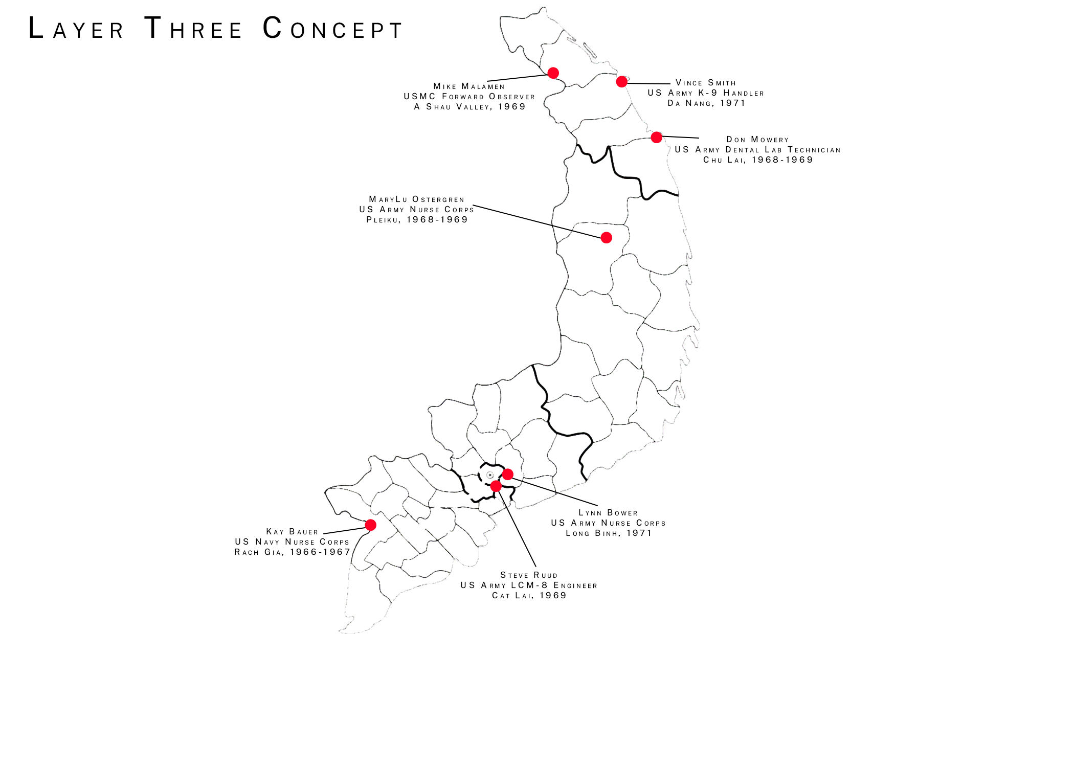
Look at the map on the right.
From your experience with the maps above, you know that Mike and the A Shau Valley are near the top of the map. Find his name and red dot.
Who is the next name? Ask around your classroom and find out who has Vince Smith. Bring the map to them so they know where he was stationed.
Continue on with the other names.
CHALLENGE: Get all seven students together in a single group and discuss their similarities and differences. Did they share the same deployment years? Location? Occupation? Home town?

“My job was to travel with a line company,” he described. “When they ran into resistance, my job was to call in the supporting fire. Then we went out on listing posts where they would drop four of us off, and we sat on top of a hill and listened and watched. If we heard something, we would call in a fire mission on it or if we saw any movement, we would call a mission on it. Then they'd bring us back, they'd extract us and bring us back, and then we'd go out with them.”
Mike was raised on a vegetable farm in Champlin, MN. He and his family grew radishes, carrots, parsnips, and several other vegetables during the harvest season, and sold blocks of ice cut from Round Lake in the winter. It was hard work, which he later indicated helped prepare him for his experiences in Vietnam. His father passed away in 1965, leaving Mike, his brother, and his mother to run the farm on their own. Shortly thereafter, though, knowing his draft number was coming up, Mike decided to enlist in the Marine Corps at age 18.
He graduated from basic training as an infantry rifleman and arrived in Vietnam in early 1969. When he reported to his unit, he was informed that they were looking for volunteers to serve as forward observers. Since he had extensive experience in orientation, map reading, and firearms from his time on the farm, he volunteered for the position. “Where we operated, there were no roads, it was all jungle. We cut our own trails through because what paths the NVA used were also booby-trapped or on the top of the ridge. You don't want to travel on the top of the ridge. You don't want to travel on the trail that's there because it might be booby-trapped. If you're on top of the ridge, you're a perfect outline for a target. We'd cut our own way through with machetes.”
Mike later described the terrible conditions of fighting in the jungle. “No sunlight. It's dark and it's hot and muggy and with no wind and bugs. Not a good place to be,” he said. “Anything would kill you. That's one place where you could die 24 hours a day, seven days a week, 365 days out of the year not even thinking about it. Somebody could take you out so fast you'd be just done… You're constantly on alert and you get used to it. You get to the point where this is what you do and this is what you got to do to survive…” In the duration of his service, he was hospitalized twice: the first after contracting malaria, and the second after he was shot in the leg.
He spent the entirety of his time in-country in an active combat zone and was frequently involved in hostile action. He and his team of radiomen would study topographical maps of the particular area they were operating in and call in airstrikes on Viet Cong positions. Some of the ordnance he called included field artillery, naval batteries, ‘Spooky’ gunships, napalm, and white phosphorus munitions (known as ‘Willie Pete’).
In November of 1969, after over a year in Vietnam, Mike was sent home to the US and discharged, but his experiences left him with painful memories and difficulty adjusting to civilian life. “It reminds me of a black-and-white film rolling in slow motion through your head,” he later recalled. “Then when the action hits or something happens, it goes into color and speeds up, and then it slows down again.” He returned home to the family farm, which he took over after his brother moved to Texas to start his own. Mike participated in an oral interview about his experiences through the Anoka County Historical Society in 2025, and currently lives in Cedar, MN, with his wife, Deanna.